# 1. 简述
在ol中对图层显隐性的控制可以通过修改图层的visible属性或设置不透明度opacity属性来实现。
与且它地图API对比,获取图层的方法比较繁琐,比如在ArcGIS for JS中使用map.getLayerById()就可直接获得对应的图层了,但在ol中添加到map中的图层都存储在一个图层集合layers中的,需要使用map.getLayers()方法先获得该集合,再循环遍历筛选才能得到想要的图层。
图层集合中先添加进来的图层在底部,会被后加入的图层遮挡。所以通常将瓦片底图放在底部,上面的图层依次按面、线、点要素添加,这样有利于各图层的显示。如果想当前图层不被遮挡可以设置后续加入图层的
opacity不透明度属性。
核心代码:
function changeLayerVisibility(layerId,prop) {
    //获取图层数组
    var layers = map.getLayers();
    for(var i=0;i<layers.getLength();i++){
        if(layers.item(i).get("id") === layerId){
            layers.item(i).setVisible(prop);
        }
    }
}
1
2
3
4
5
6
7
8
9
2
3
4
5
6
7
8
9
相关API:

map.getLayers()返回的是图层(BaseLayer)集合对象。
ol.Collection是对JS中数组的扩展,添加许多方便的方法,如item(index)方法获取相应index位置的数组元素。BaseLayer是Layer的基类。
在构建Layer时,传入的option都会有相应的get/set访问器,所以可以拿到初始化图层时自定义的id属性。
# 2. 示例
这里使用了一个很久很久以前比较流行的js树形插件ztree。
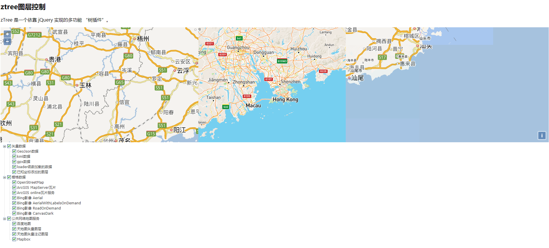
下面我们使用ztree树形插件来创建图层控制示例(完整代码):
<!doctype html>
<html lang="en">
<head>
    <meta charset="utf-8">
    <style>
        .map {
            height: 400px;
            width: 100%;
        }
    </style>
    <link rel="stylesheet" href="css/ol.css" type="text/css">
    <link rel="stylesheet" href="lib/zTree_v3/css/zTreeStyle/zTreeStyle.css" type="text/css">
    <script src="lib/ol.js"></script>
    <script src="lib/jquery-3.1.1.js"></script>
    <script src="lib/zTree_v3/js/jquery.ztree.all.min.js"></script>
    <title>Layer</title>
</head>
<body>
<h2>ztree图层控制</h2>
<p>zTree 是一个依靠 jQuery 实现的多功能 “树插件”。</p>
<div id="map" class="map"></div>
<div id="treeDemo" class="ztree"></div>
<script type="text/javascript">

    var zTreeObj;
    // zTree 的参数配置,深入使用请参考 API 文档(setting 配置详解)
    var setting = {
        check: {
            enable: true,
            nocheckInherit: false
        },
        data: {
            simpleData: {enable: true}
        },
        view:{
            showIcon:false
        },
        callback:{
            //配置复选框点击事件的处理函数
            onCheck:handleCheck
        }
    };
    // zTree 的数据属性,深入使用请参考 API 文档(zTreeNode 节点数据详解)
    var zNodes = [
        {
            Id:1,pid:0,name:"矢量数据", open:true, checked:true,children:
            [
                {id:11,pId:1,name:"GeoJson数据",id:"GeoJsonData", checked:true},
                {id:12,pId:1,name:"kml数据",id:"kmlData", checked:true},
                {id:13,pId:1,name:"gpx数据",id:"gpxData", checked:true},
                {id:14,pId:1,name:"loader函数加载的数据",id:"load", checked:true},
                {id:15,pId:1,name:"已知坐标添加的图层",id:"pointLayer", checked:true},
            ]
        },
        {
            id:2,pId:0,name:"栅格数据", open:true, checked:true,children:
            [
                {id:21,pId:2,name:"OpenStreetMap",id:"osm", checked:true},
                {id:22,pId:2,name:"ArcGIS MapServer瓦片",id:"arcgis_tile", checked:true},
                {id:23,pId:2,name:"ArcGIS online瓦片服务",id:"arcgis_online", checked:true},
                {id:24,pId:2,name:"Bing影像 Aerial",id:"bing_Aerial", checked:true},
                {id:25,pId:2,name:"Bing影像 AerialWithLabelsOnDemand",id:"bing_AerialWithLabelsOnDemand", checked:true},
                {id:26,pId:2,name:"Bing影像 RoadOnDemand",id:"bing_RoadOnDemand", checked:true},
                {id:27,pId:2,name:"Bing影像 CanvasDark",id:"bing_CanvasDark", checked:true},
            ]
        },
        {
            id:3,pId:0,name:"公共网络地图服务",open:true,checked:true,children:
            [
                {id:31,pId:3,name:"百度地图",id:"BMap", checked:true},
                {id:32,pId:3,name:"天地图矢量图层",id:"tdt_vec", checked:true},
                {id:33,pId:3,name:"天地图矢量注记图层",id:"tdt_cva", checked:true},
                {id:34,pId:3,name:"Mapbox",id:"mapbox_tile", checked:true},
            ]
        }
    ];
    $(document).ready(function(){
        zTreeObj = $.fn.zTree.init($("#treeDemo"), setting, zNodes);
    });
    //ztree复选框点击事件处理函数
    function handleCheck(e,treeId,treeNode){
        if(treeNode.level !== 0){
            //叶子节点时
            changeLayerVisibility(treeNode.id,treeNode.checked)
        }else{
            //非叶子节点时
            if(treeNode.children !== null){
                for(var j=0;j<treeNode.children.length;j++){
                    changeLayerVisibility(treeNode.children[j].id,treeNode.checked);
                }
            }
        }
    }

    function changeLayerVisibility(layerId,prop) {
        var layers = map.getLayers();
        for(var i=0;i<layers.getLength();i++){
            if(layers.item(i).get("id") === layerId){
                layers.item(i).setVisible(prop);
            }
        }
    }

    //初始化地图,加载图层
    var map;
    function initMap() {
        var shenzhen = [113.958334, 22.535640];
        var url =  'https://sampleserver1.arcgisonline.com/ArcGIS/rest/services/Specialty/ESRI_StateCityHighway_USA/MapServer';
        var onlineTileUrl =  'http://server.arcgisonline.com/arcgis/rest/services/USA_Topo_Maps/MapServer/tile/{z}/{y}/{x}'
        var bingKey = 'AmosL5A0GtVryl4sXNZm6U5EQMD6brAd5E8AJPGJf8AUU1saDYXDkb5CwQFijans';
        var key = "bf156eb3c72350d62b008dc8a4ae1016";
        var mapboxkey = "pk.eyJ1IjoicWl1c2hpamllIiwiYSI6ImNrYTYzNmlhdDAzb2YydG13YjZic2t2M3AifQ.XiCKl8HOEAy0MBo5v2yjvA";
        var vectorSource = new ol.source.Vector({
            format: new ol.format.GeoJSON(),
            loader: function (extent, resolution, projection) {
                var proj = projection.getCode();
                var url = 'http://gisserver.tianditu.gov.cn/TDTService/wfs?service=WFS&' +
                    'version=1.1.0&request=GetFeature&typename=LRRL&' +
                    'outputFormat=application/json&srsname=' + proj + '&' +
                    'bbox=' + extent.join(',') + ',' + proj;
                var xhr = new XMLHttpRequest();
                xhr.open('GET', url);
                var onError = function () {
                    vectorSource.removeLoadedExtent(extent);
                }
                xhr.onerror = onError;
                xhr.onload = function () {
                    if (xhr.status == 200) {
                        vectorSource.addFeatures(
                            vectorSource.getFormat().readFeatures(xhr.responseText));
                    } else {
                        onError();
                    }
                }
                xhr.send();
            },
            strategy: ol.loadingstrategy.bbox
        })
        var pointFeature = new ol.Feature({
            geometry: new ol.geom.Point([12703928.421,2575539.521]),
            name: '点要素'
        });
        var resolutions = [];
        for(var i=0;i<19;i++){
            resolutions[i] = Math.pow(2,18 - i)
        }

        map = new ol.Map({
            target:"map",
            view: new ol.View({
                center:ol.proj.fromLonLat(shenzhen),
                zoom:8
            }),
            layers:[
                //加载矢量Vector服务图层
                new ol.layer.Vector({
                    source:new ol.source.Vector({
                        url:'data/geojson/countries.geojson',
                        format:new ol.format.GeoJSON()
                    }),
                    name:"国界(JSON格式的矢量图层)",
                    id:"GeoJsonData"
                }),
                //加载矢量Vector服务图层
                new ol.layer.Vector({
                    source:new ol.source.Vector({
                        url:'data/kml/2012_Earthquakes_Mag5.kml',
                        format:new ol.format.KML({
                            extractStyles:false
                        })
                    }),
                    name:"点(KML格式的矢量图层)",
                    id:"kmlData"
                }),
                new ol.layer.Vector({
                    source:new ol.source.Vector({
                        url:'data/gpx/fells_loop.gpx',
                        format:new ol.format.GPX()
                    }),
                    name:"GPX数据",
                    id:"gpxData"
                }),
                new ol.layer.Vector({
                    source: vectorSource,
                    name: "天地图中的道路数据",
                    id: "load"
                }),
                new ol.layer.Vector({
                    source: new ol.source.Vector({
                        features:[pointFeature]
                    }),
                    id:"pointLayer"
                }),
                //加载瓦片图层
                new ol.layer.Tile({
                    source:new ol.source.OSM(),
                    name:"世界地图(OSM瓦片)",
                    id:"osm"
                }),
                new ol.layer.Tile({
                    // extent:[-13884991, 2870341,  -7455066, 6338219],
                    source:new  ol.source.TileArcGISRest({
                        url:url
                    }),
                    name:"ArcGIS瓦片服务",
                    id:"arcgis_tile"
                }),
                new ol.layer.Tile({
                    // extent:[-13884991, 2870341,  -7455066, 6338219],
                    source:new  ol.source.XYZ({
                        url:onlineTileUrl
                    }),
                    name:"ArcGIS online瓦片服务",
                    id:"arcgis_online"
                }),
                new ol.layer.Tile({
                    source:new ol.source.BingMaps({key:bingKey,imagerySet:"Aerial"}),
                    name:"BingMaps(Aerial)",
                    id:"bing_Aerial"
                }),
                new ol.layer.Tile({
                    source:new ol.source.BingMaps({key:bingKey,imagerySet:"AerialWithLabelsOnDemand"}),
                    name:"BingMaps(AerialWithLabelsOnDemand)",
                    id:"bing_AerialWithLabelsOnDemand"
                }),
                new ol.layer.Tile({
                    source:new ol.source.BingMaps({key:bingKey,imagerySet:"RoadOnDemand"}),
                    name:"BingMaps(RoadOnDemand)",
                    id:"bing_RoadOnDemand"
                }),
                new ol.layer.Tile({
                    source:new ol.source.BingMaps({key:bingKey,imagerySet:"CanvasDark"}),
                    name:"BingMaps(CanvasDark)",
                    id:"bing_CanvasDark"
                }),
                new ol.layer.Tile({
                    id:"BMap",
                    source:new ol.source.TileImage({
                        //设置坐标参考
                        projection:ol.proj.get('EPSG:3857'),
                        //设置分辨率
                        tileGrid:new ol.tilegrid.TileGrid({
                            origin:[0,0],
                            resolutions:resolutions
                        }),
                        //设置百度地图的瓦片地图请求地址
                        tileUrlFunction:function (tileCoord,pixelRatio,proj) {
                            if(!tileCoord){
                                return "";
                            }
                            var z = tileCoord[0];
                            var x = tileCoord[1];
                            var y = tileCoord[2];

                            if(x < 0){
                                x = "M" + (-x);
                            }
                            if(y < 0){
                                x = "M" + (-y);
                            }
                            return "http://online3.map.bdimg.com/onlinelabel/?qt=tile&x=" + x + "&y=" + y + "&z=" + z + "&style=pl&udt=20151021&scale=1&p=1";
                        }
                    })
                }),
                new ol.layer.Tile({
                    id:"tdt_vec",
                    title:"天地图矢量图层",
                    source:new ol.source.XYZ({
                        // url:"http://t0.tianditu.gov.cn/vec_w/wmts?SERVICE=WMTS&REQUEST=GetTile&VERSION=1.0.0&LAYER=vec&STYLE=default&TILEMATRIXSET=w&FORMAT=tiles&TILECOL={x}&TILEROW={y}&TILEMATRIX={z}&tk="+key,
                        url: 'http://t' + Math.round(Math.random() * 7) + '.tianditu.com/DataServer?T=vec_w&x={x}&y={y}&l={z}&tk='+key,
                        crossOrigin:"anonymous",
                        wrapX:false
                    })
                }),
                new ol.layer.Tile({
                    id:"tdt_cva",
                    title:"天地图矢量注记图层",
                    source:new ol.source.XYZ({
                        url:"https://t2.tianditu.gov.cn/DataServer?T=cva_w&x={x}&y={y}&l={z}&tk="+key,
                        crossOrigin:"anonymous",
                        wrapX:false
                    })
                }),
                new ol.layer.Tile({
                    id:"mapbox_tile",
                    source: new ol.source.XYZ({
                        url: 'https://api.mapbox.com/styles/v1/mapbox/streets-v11/tiles/256/{z}/{x}/{y}?access_token='+mapboxkey
                    })
                }),
            ]
        });
    }
    window.onload = initMap();
</script>
</body>
</html>
1
2
3
4
5
6
7
8
9
10
11
12
13
14
15
16
17
18
19
20
21
22
23
24
25
26
27
28
29
30
31
32
33
34
35
36
37
38
39
40
41
42
43
44
45
46
47
48
49
50
51
52
53
54
55
56
57
58
59
60
61
62
63
64
65
66
67
68
69
70
71
72
73
74
75
76
77
78
79
80
81
82
83
84
85
86
87
88
89
90
91
92
93
94
95
96
97
98
99
100
101
102
103
104
105
106
107
108
109
110
111
112
113
114
115
116
117
118
119
120
121
122
123
124
125
126
127
128
129
130
131
132
133
134
135
136
137
138
139
140
141
142
143
144
145
146
147
148
149
150
151
152
153
154
155
156
157
158
159
160
161
162
163
164
165
166
167
168
169
170
171
172
173
174
175
176
177
178
179
180
181
182
183
184
185
186
187
188
189
190
191
192
193
194
195
196
197
198
199
200
201
202
203
204
205
206
207
208
209
210
211
212
213
214
215
216
217
218
219
220
221
222
223
224
225
226
227
228
229
230
231
232
233
234
235
236
237
238
239
240
241
242
243
244
245
246
247
248
249
250
251
252
253
254
255
256
257
258
259
260
261
262
263
264
265
266
267
268
269
270
271
272
273
274
275
276
277
278
279
280
281
282
283
284
285
286
287
288
289
290
291
292
293
294
295
296